Snow, strong winds, heavy rain for some

RNZ
25 October 2023, 8:39 PM
 There are strong wind warnings on Thursday. PHOTO: RNZ
Heavy rain, severe gale northwesterlies, and snow are sweeping through parts of central and southern New Zealand, with more warnings expected in the coming days.
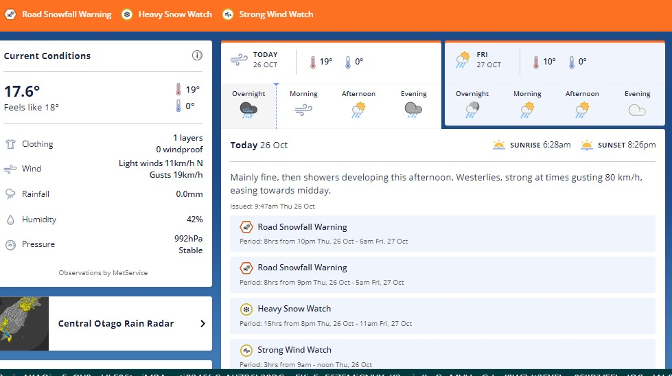
An active front over the Tasman Sea will move northwards over southern and central New Zealand on Thursday.
MetService said this front would be preceded by a strong and moist northwesterly flow, and followed by strong and cold west to southwesterlies.
Heavy rain warnings are in place for Buller, Westland and the headwaters of Canterbury lakes and rivers about and south of Arthur's Pass.
There are strong wind warnings for Wairarapa, Wellington, the Marlborough Sounds and Canterbury High Country.
Several parts of the South Island and lower North Island are also under rain, wind and snow watches.
Cold temperatures, snow to follow warm spell
MetService head of weather communications Lisa Murray told Morning Report the rain was mostly focused on the western side and the wind on the eastern side of the country.
Several places including Napier and Dunedin would have warm temperatures ahead of today's front, she said.
"But behind that front, there's going to be a significant drop in temperature."
Snow was also expected tonight for Fiordland, Southland, Clutha, Dunedin, Central Otago and Southern Lakes.
She said Napier and Hastings would be in the mid-20s.
But behind that front, she said there would be a sharp drop in temperature.
She said Dunedin, for example, would be a maximum of 21 degrees Celsius on Thursday, but on Friday that would drop to only 8-9C, with an overnight temperature of 3C.
Waka Kotahi journey planner Nicole Felts urged extra caution on the road and expect wintery conditions.
She told Morning Report people may not be expecting snow down near sea level in places like Otago and Southland at this time of year.
"[We're] asking that people drive a bit slower than they normally would and make sure that they're accelerating smoothly, braking gently, taking their time if they do absolutely need to travel tonight."
She also urged caution for those driving in heavy rain or winds.
Central, expect and plan for snow and wind over the next 48 hours. Source: MetService
Cyclone Lola
MetService was also keeping an eye on Cyclone Lola.
Murray said the cyclone had weakened from its level 5 status as its remnant moves towards the Tasman Sea.
"Then when we get this cold air that's coming up, bringing the snow and the rain and the wind to us, meets that in the Tasman Sea on Saturday, and it sort of reinvigorates the energy of that storm."
Murray said a low was expected to come on to the country. Northland, Auckland and Napier were among those first expected to be affected.
Updates relevant to our area will be updated in Roads special Spring section.Spring Road and Weather report