Wettest, warmest winter ever

Anna Robb
05 September 2022, 5:30 PM
 NIWA scientists confirmed this winter smashes records across New Zealand - for rainfall and warm temperatures. PHOTO: Supplied
 If you thought this past winter had been wet, wet, wet and unusually warm you’re on the money, as many rainfall and temperature records were broken across Aotearoa.
MetService meteorologist Lewis Ferris said he had looked at data for Alexandra back to 1922.
“This winter period is actually the second wettest in that time and while there are a few gaps in the data, the winter period would typically see 60-70mm while this winter ticked up 150mm at our station.”
The winter of 2013 was slightly wetter than 2022, with 162mm of rainfall, Lewis said.
The Nelson Airport weather station smashed its previous winter record of 570mm set in 1970. The area ticked up 701mm and exceeded its winter average rainfall in over four consecutive days last month alone (August 17 – 20).
Other regions of the South Island were unusually wet: Christchurch, Timaru, Wānaka, and Hokitika airports all set new winter records, with Hokitika recording a whopping 1142mm – more than 400mm above their winter average.
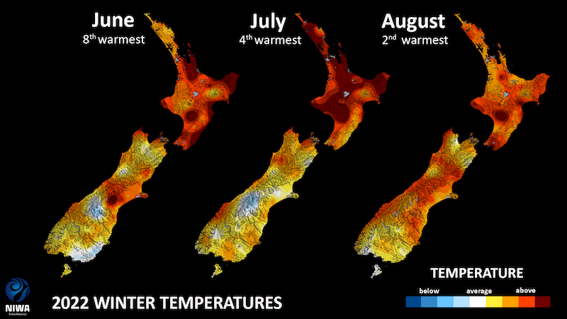
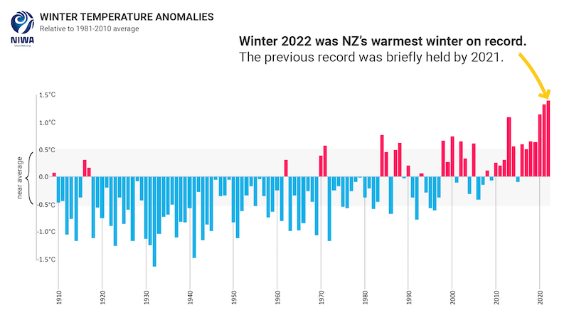
NIWA scientists confirmed it was our warmest* and wettest** on record.
It was the third consecutive warmest winter, and every winter month was warm with NIWA calling it a “three peat”.
“Each of the individual months had at least a temperature anomaly of +1.2 degrees, the first time on record we’ve seen that,” NIWA forecaster Ben Noll said.
Nationwide the temperature was 9.8’C (1.4’C above the 1981 - 2010 average). Eighty-four locations experienced a record or near record warm winter. The lowest temperature recorded was -11.6’C at Aoraki on July 17, and the highest was 24.3’C at Wairoa on August 24.
Forty-two locations experienced a record or near record wet winter. The highest day of rainfall was 371mm at Mt Cook village on July 18.
NIWA said it snowed a lot in the South Island but it didn’t necessarily last; Aoraki/Mt Cook Village had its deepest snowpack on record (since 2010) in mid-July.
NIWA science communicator Nava Fedaeff said it was an early start to the snow season in the South Island in June and July.
“Then we had a lot of rain on snow events... now most of our high elevation climate stations…have below normal snow depths.”
She said it was a “mixed bag and variable” ski season especially in the North Island humidity presented more challenges for snow making at Ruapehu.
Several factors contributed to the record breaking wet and warm winter. La Niña brings with it an increased frequency of rain bringing weather systems approaching from the north.
A negative Indian Ocean Dipole (IOD) was present throughout winter as well. When this occurs alongside La Niña, it further increases the potential of northerly rainfall events. The good news is this should ease over summer.
A warmer atmosphere due to climate change is strongly contributing to New Zealand’s temperature trend. Because a warmer atmosphere means water will be in its vapour state (more fuel for rain), it is likely that the extreme rainfall events of winter 2022 were more intense because of the warmer climate.
NIWA’s spokesperson said the warming temperatures mean that all seasons are getting warmer and therefore “summer-like” temperatures can now be experienced in spring and autumn.
The number of frosts are also decreasing which affects agricultural seasons.
For more weather information check out NIWA’s video winter summary here.
*Based on NIWA’s seven station temperature series which began in 1909
** Based on NIWA’s virtual climate station network which extends back to 1971


