The week’s weather

Rowan Schindler
31 May 2021, 3:33 AM
 Central Otago will enjoy a brief reprieve from wet weather early this week, before some rain returns towards the weekend.
 Central Otago will gradually dry out of the next few days as wild weather which has caused havoc in Canterbury, passes through.
Several roads and areas in Central Otago have been affected by rain water, with roads closed in the Maniototo, as well as conserve water notices in affect for Ranfurly, Patearoa and Naseby.
The rain will briefly return towards the end of the week though, as temperatures barely scrape above the low teens.
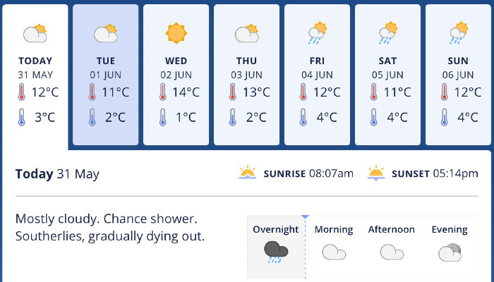
Tuesday is forecasted to bring morning clouds and a chance of showers, then fine spells with light winds, while Wednesday will include morning fog or frosts, then fine.
Thursday will be partly cloudy with possible morning frosts, while Friday will include cloud and northerlies increasing with a few showers developing later in the day.
Saturday is forecasted to be cloudy, with rain developing, while Sunday will feature a few showers with light winds.
Central Otago will briefly dry out early this week before showers return by the weekend. Image: MetService.
MetService Meterologist Angus Hines says the remaining showers will clear up and then the weather will trend to fine but cool.
The heavy, persistent rain which has saturated much of the eastern South Island this weekend persists in parts of Canterbury, but it’s a more showery regime which kicks off the week in Central Otago.
“Remaining showers should clear in the first half of Tuesday, then the rest of the week will be dry.
“Temperatures will be fitting for the first week of winter, so expect cold and frosty mornings each day.
“Overhead conditions will be a mixture of sunshine and cloud until late Friday, when some scattered rain could round out the week.”
A severe heavy rainfall event is still under a heavy rain warning for Canterbury. Heavy rain also for parts of Marlborough. Severe gales for parts of the South Island.
A humid southeast flow is expected to bring further heavy rain to parts of Canterbury, which remain under a Red Warning, although rain is easing or expected to ease during the course of the day. A heavy rain Warning (orange) also remains in force for Marlborough about and south of Kaikoura.
In addition, severe gale south easterlies are expected along coastal areas of Canterbury about and north of Banks Peninsula this morning, while a Watch remains in force for coastal areas of Marlborough.
This is a severe heavy rainfall event for Canterbury. Dangerous river conditions and widespread flooding are still ongoing in some areas. Slips and floodwaters are disrupting travel, making some roads impassable and isolating communities. Further power outages are also likely.
People are advised to keep up to date with the latest forecasts and any advice from local authorities.


