The week’s weather

Rowan Schindler
04 January 2021, 10:52 PM
 A wet start to the week should give way to a warmer and partly cloudy Central Otago, according to MetService.
 The wet start to 2021 looks set to continue but not to the same extent as last week.
A Heavy Rain Watch has been issued for parts of Otago and Canterbury Hill Country for this evening.
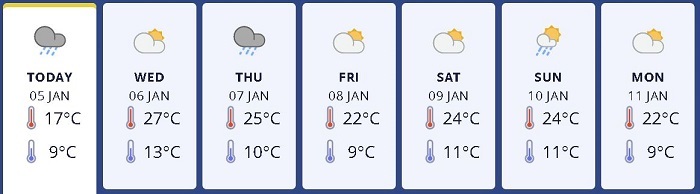
Temperatures will rise with Wednesday set for the high 20s, while rain continues to persist.
"While today is a mostly dry day for the North Island, in the South a front will bring some rain," the MetService warning says.
"Although the east will on average see much less than the west, a Heavy Rain Watch has just been issued for Otago, the south Canterbury Hill Country and northern Dunedin for this evening.
"These areas have a risk of some heavy falls between 5pm and 11pm tonight, and this could cause issues in the areas that have only recently been flooded.
"Late on Wednesday another front reaches the far south, bringing rain to South Island on Thursday (again, mostly in the west) and the North Island on Friday, although by then the front will have weakened so amounts in the north will be less than the south."
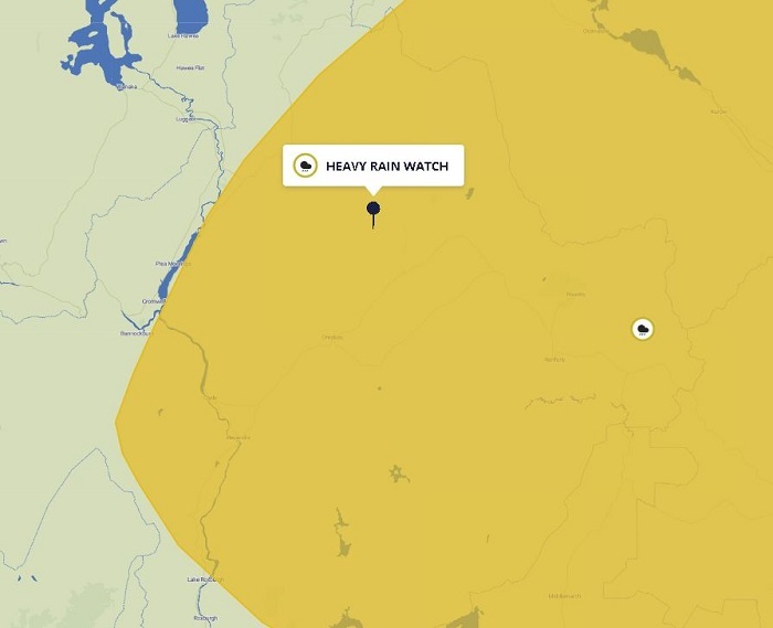
A Heavy Rain Watch has been issued for part of Otago, including Clyde, Alexandra, Omakau and the Maniototo.
Last week, temperatures dropped as the region suffered surface flooding, with parts of Central Otago still grappling with the effects.
Naseby, Ranfurly, Patearoa all have Boil Water Notices, while Roxburgh has been notified with a Conserve Water Notice for residents to limit water usage.
Cromwell-raised MetService Meteorologist Lewis Ferris said the temperatures will get back into the 20s this week, while rain will continue to fall across the region.
“After a very damp start to 2021 there is more wet weather on the way but not to the same extent,” Lewis said.
“Alexandra Airport clocked up 97.4mm of rain on the 2nd which is more than ten times the amount that was recorded there in all of January 2020 (9.2mm).
Central Otago will experience more rain this week.
“A Heavy Rain Watch is in force from 5pm this evening (Tuesday) until 11pm and while the accumulations don’t look likely to approach Warning amounts, the already saturated areas could see some water pooling.”
Lewis said Wednesday will see the mercury rise suddenly.
“Wednesday sees a big jump in temperature from the 17C forecast on Tuesday up to 27C,” he said.
“However wet weather looks to become more widespread across the region through the second half of the day.
“Heading into Thursday the temperature remains around the mid-twenties but we’ve got a showery situation on our hands.
“While not everyone will see them, there is a risk of thunderstorms from the afternoon into evening.
“Friday through Sunday is looking a lot more settled at this point. Temperatures hovering around the mid to low 20s with possible isolated showers.”


