Rain eases, lake and lagoon levels still monitored
Staff Reporter
24 October 2025, 3:00 AM
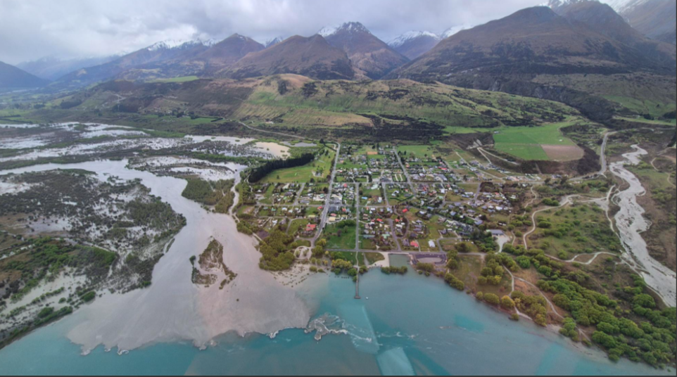 Glenorchy township about 2pm Friday, about an hour before the Glenorchy Lagoon peak. Photo: Jono Young/ORC.
Heavy rain has eased across Otago but lakes and lagoons remain under close watch by the Otago Regional Council.
Lakes Whakatipu and Wānaka, along with Glenorchy Lagoon, are expected to peak by Saturday morning, though at the lower end of earlier predictions.
MetService lifted its southern orange rain and wind warnings on Thursday night, following a significant easing in rainfall over the Otago headwaters earlier that afternoon.
ORC General Manager Science and Resilience Tom Dyer said most Otago river flows peaked on Thursday morning, and lake level rises have since slowed.
“Some rain remains in the Otago forecast for today. It’s below the MetService watch and warning thresholds, but due to the current conditions, we’ll continue monitoring all river and lake
flows, including the lower Clutha catchment, through the long weekend,” Tom said.
He cautioned that lakes could rise further due to forecast rain on Monday, but it was too early to quantify the potential impact.
“As the lake levels are already elevated, we’ll maintain a continuous watch,” he said.
Lake levels by Saturday morning
Lake Whakatipu is expected to remain steady or rise slightly, peaking between 311.1m and 311.3m. The lake typically begins to inundate Rees and Beach Streets via the stormwater system
around 311.3m. Sandbags are already in place along parts of the foreshore as a precaution.
Lake Wānaka is also predicted to hold steady or rise slightly, peaking between 279.2m and 279.4m. Some inundation of lake reserve land is expected, but this level remains about 600mm
below the lower sections of nearby Ardmore Street.
Glenorchy Lagoon is forecast to rise again late Friday night or early Saturday morning but is not expected to exceed the overtopping threshold of the Glenorchy floodbank.
“However, some low-lying areas of Glenorchy, and also the Kingston township foreshore, could begin to be affected,” Tom said.
Looking ahead: MetService forecast for Monday
A complex trough from the Tasman Sea is expected to move across New Zealand on Monday, bringing significant weather to many areas, including snow to relatively low levels across the
eastern South Island.
MetService has:
- Moderate confidence of heavy rain in western Tasman, Buller, Grey, northern Westland, and parts of the Canterbury High Country.
- Low confidence of significant rain in eastern and Central Otago.
- Low confidence of heavy snow to 500m for Central Otago and the Canterbury high country.
NEWS