Wild week continues with more strong winds for Central Otago

Kim Bowden
21 October 2025, 11:28 PM
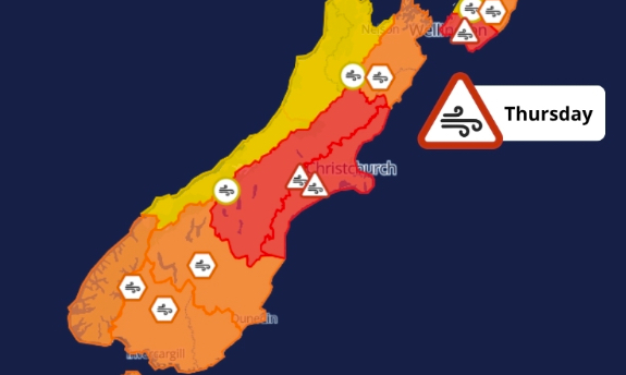 Image: MetService
Central Otago residents are being urged to secure loose items outside as strong northwesterly winds are forecast to sweep through the region early Thursday morning.
MetService has issued an orange strong wind warning for Otago, effective from 3am to 2pm on Thursday (October 23).
Severe gale northwesterlies are expected, with gusts reaching up to 130 kilometres an hour in exposed areas.
MetService said there was potential for "damage to trees, powerlines, and unsecured structures" and warned "driving may be difficult, especially for high-sided vehicles and motorcycles".
Residents are being advised to prepare by securing trampolines, outdoor furniture, and any items that could be picked up by strong gusts.
It is forecast to be a rough night across much of the country, with a raft of severe wind and rain warnings in place.
In Canterbury, MetService is warning of possible threats to life as gusts could reach up to 150 kilometres an hour in some exposed areas.
There remains a moderate chance wind speeds could strengthen further in Otago, prompting a red-level warning.
A heavy rain warning is also in place for the headwaters of the Otago lakes and rivers, from 1am to 12pm on Thursday.
Forecasters expect 140 to 200 millimetres of rain about the main divide, and 80 to 150 millimetres within 40 kilometres farther east.
Peak rates of 30 to 40 millimetres an hour are possible on Thursday morning, with thunderstorms and a snow level of 2500 metres.
After a brief respite midweek, Thursday’s warning follows a run of turbulent spring weather across Central Otago, including wild winds earlier in the week and snow falling to lower levels on Monday.
