The week’s weather

Rowan Schindler
09 May 2021, 11:11 PM
 Chilly weather will move into Central Otago this week with the potential for snow down to 600m.
Wave goodbye to warm weather as chilly fronts move into Central Otago this week, which could bring the potential for snow according to MetService.
Cromwell-raised MetService Meteorologist Lewis Ferris says to say goodbye to the heat
“The last two weeks has seen daytime maximum temperatures on the warmer side of average but with some chilly mornings,” Lewis says.
“This morning (Monday) Alexandra was around 10 degrees at dawn.
“Another warm start is forecast on Tuesday but come Wednesday you’ll be back in frost territory for a good wee while with afternoon maximums around the low teens.”
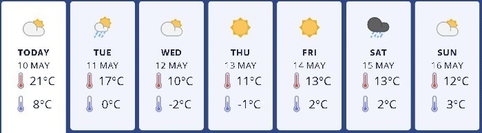
Central Otago will experience frosts and the potential for snow down to 600m this week, according to MetService.
Lewis says a change in weather will bring the potential for snow to the region on Tuesday and frosts throughout the week.
“A cold front is forecast to bring rain to the region on Tuesday with the potential of snow falling to around the 600m mark.
“Northwesterly winds will be reasonably gusty about the ranges before the front arrives but then it is the southerlies, precipitation and wind chill which could cause issues for livestock later on Tuesday and into Wednesday.
“The wind shifting from north to south is what marks the arrival of the cooler air which tends to linger into the rest of the week.
“The wet weather is short lived, with settled but cool conditions expected from Wednesday through to the weekend.
“At this point a front looks to pass over Central Otago from the west on Saturday which will mean strong northerly winds for elevated areas before the arrival of the rain, albeit not large amounts in urban areas.”
Advertisement