Notice: SH8 detours in Roxburgh

Rowan Schindler
15 April 2021, 5:30 AM
 Replacement work for a flood relief culvert will take place in Roxburgh in April.
 Waka Kotahi NZ Transport Agency (NZTA) will begin replacement work on a culvert as part of the flood relief project getting underway in Roxburgh.
The work will impact on SH8 in Roxburgh, with a full detour for eight days, from 18 April to 26 April.
From 8am Sunday, 18 April to 8 am Monday, 26 April, there will be a 24/7 traffic closure as the old culvert is removed and the new one is positioned. This closure coincides with the school holidays and Anzac Day observance on Monday, 26 April.
The detour route, on the eastern side of the Clutha River, will take northbound traffic in Roxburgh onto Jedburgh St across the river, onto Roxburgh East Road up to the Roxburgh Hydro Dam and back onto SH8.
A one-metre square culvert will be replaced by one eight times bigger north of Roxburgh, at Pumphouse Creek on SH8 in coming weeks, says Waka Kotahi NZ Transport Agency.
The new culvert will measure four metres by two metres.
"The main impact upon road users will be a full road closure with a detour from Sunday, 18 April to Monday morning, 26 April,” Waka Kotahi Maintenance Contract Manager Mark Stewart says.
Pumphouse Creek is half a kilometre north of Roxburgh.
“Following a series of floods over recent years in the Roxburgh area, a catchment study was conducted by Otago Regional Council, and Waka Kotahi has been working closely with council staff to help improve the resilience of this section of SH8 to protect land and the downstream water treatment plant in sustained heavy rain.”
Pumphouse Creek had an ongoing risk of flooding, he says.
“Gravel was accumulating and blocking the existing culvert following heavy rain in the hills which has occurred more frequently over recent years.
“Not only is the existing culvert unable to deal with these heavy rain events, an existing water treatment pumphouse owned by Central Otago District Council immediately downstream also becomes vulnerable to damage and possible outages to the residents of the town when it floods.
“The larger culvert will help channel flood waters and gravels under the road and below the pumphouse to the Clutha River once it is operational.”
The work programme and the detour/ road closure from 18 April
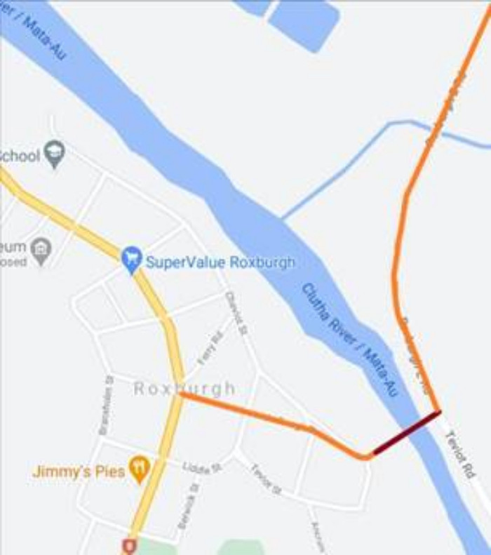
Sample map of the detour route across the Clutha river, Roxburgh. Image courtesy NZTA/Google Maps.
Local road users may need an extra 10 – 15 minutes to navigate via the detour when travelling around their community, however vehicles that were intending to travel straight through Roxburgh via SH8 will have less than five minutes added to their total journey.
Pedestrians and cyclists
Pedestrians and cyclists will be helped through the work site during daytime hours of operation – 8 am to 5 pm – even while the eight-day detour and traffic closure is in place.
Residents are asked to keep pets and children away from the site as much as possible over the next few weeks, given the heavy machinery being used.
Detour route – not suitable for all freight/ over-dimension vehicles
The detour route, on the eastern side of the Clutha River, is not suitable for all freight traffic and over-dimension vehicles.
- While High Performance Motor Vehicles (HPMV) can take the detour route, the Jedburgh bridge cannot take 50MAX truck trailers, overweight freight vehicles and over-dimension vehicles are restricted to nine metres wide.
- At the Roxburgh Dam bridge, over-dimension loads are further restricted to 6.5 metres wide and 7 metres high.
“Waka Kotahi thanks all regular road users and residents for taking care around this work site, our crews and on the detour route through to the end of May.”
Key points:
From 8 am Sunday, 18 April to 8 am Monday, 26 April, there will be a 24/7 traffic closure as the old culvert is removed and the new one is positioned. This closure coincides with the school holidays and Anzac Day observance on Monday, 26 April.
The detour route, on the eastern side of the Clutha River, will take northbound traffic in Roxburgh onto Jedburgh St across the river, onto Roxburgh East Road up to the Roxburgh Hydro Dam and back onto SH8. (Reverse for southbound traffic – see maps below).
Pedestrians and cyclists
Pedestrians and cyclists will be helped through the work site during daytime hours of operation – 8 am to 5 pm – even while the eight-day detour and traffic closure is in place. Residents are asked to keep pets and children away from the site as much as possible over the next few weeks, given the heavy machinery being used.
Detour route – not suitable for all freight and over-dimension vehicles
The detour route, on the eastern side of the Clutha River, is not suitable for all freight traffic and over-dimension vehicles.
· While High Performance Motor Vehicles (HPMV) and 50MAX truck trailers can take the detour route, overweight vehicles and some over-dimension loads will not be able to be accommodated.
· The maximum OD vehicle dimensions allowed on the detour is 6.5 m wide and 7.0 m high.
Waka Kotahi thanks all regular users of this route and affected residents for their patience around this road closure and detour. Further appreciation is given for road users care taken around the work site and our crews through to the end of May.
Remember to check The Central App roads as this is updated as and when information comes in daily click here Roads


