NIWA: Hotter and drier summer likely for Central

Rowan Schindler
30 November 2020, 4:26 PM
 A National Institute of Water and Atmospheric Research (NIWA) report indicates Central Otago is likely to be hotter and drier than average this summer.
 A National Institute of Water and Atmospheric Research (NIWA) report has cast its look forward to the next three months, with below average rainfall and above average temperatures likely for Central Otago.
The Summer Climate Outlook report indicates the likelihood of climate conditions being at, above, or below average for the season as a whole.
NIWA stressed it is not a ‘weather forecast’ as it is not possible to forecast precise weather conditions three months in advance.
The outlooks are the result of the expert judgment of NIWA’s climate scientists and take into account observations of atmospheric and ocean conditions and output from global and local climate models.
The presence of El Niño or La Niña conditions and the sea surface temperatures around New Zealand can be a useful indicator of likely overall climate conditions for a season.
“Consistent with moderate La Niña conditions, December 2020–February 2021 air pressure is forecast to be higher than normal over and to the southeast of the South Island and lower than normal to the northwest of New Zealand,” the report states.
“This is expected to be associated with northeasterly air flow anomalies.”
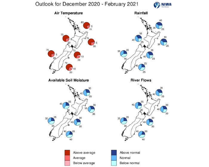
As for Central Otago, according to NIWA, temperatures are very likely to be above average (75% chance).
Rainfall totals are about equally likely to be below normal (40% chance) or near normal (35% chance).
Soil moisture levels and river flows are about equally likely to be below normal (40% chance) or near normal (35% chance).
Yesterday, the Otago Regional Council (ORC) urged irrigators and other water users to be mindful of the summer conditions as New Zealand enters a La Niña summer characterised by warmer and drier conditions than usual in the south.
“Although patterns of higher than normal pressure and drier conditions are expected to start summer, moist, sub-tropical disturbances are expected to reach the country occasionally, particularly the North Island and northern South Island.”
Graphical representation of the regional probabilities
These systems can cause areas of heavy rainfall and flooding to the North Island and northern parts of the South Island.
“Marine heatwave conditions formed near the northern North Island and northern Tasman Sea during November. Unusually warm seas in other coastal regions may develop into a marine heatwave over summer.”
Air temperatures are very likely to be above average in all regions of the country with elevated humidity levels from time to time, particularly in the North Island.
Rainfall is about equally likely to be near normal or below normal in the east and west of the South Island and about equally likely to be near normal or above normal in all remaining regions of the country.
“Extended dry spells may be interspersed with the expected unsettled periods.
“For the tropical cyclone season (November 2020-April 2021), NIWA’s Southwest Pacific Tropical Cyclone Outlook indicates that the risk for New Zealand is elevated.
“On average, one ex-tropical cyclone passes near the country each year. Significant rainfall, damaging winds, and coastal inundation can occur during these events.
“Soil moisture levels are about equally likely to be near normal or below normal in the west of both islands and the east of the South Island and most likely to be near normal in the north of both islands. There is no strong guidance for the east of the North Island.
The report indicates river flows are about equally likely to be near normal or below normal in the west and east of the South Island, about equally likely to be near normal or above normal in the north of the North Island, and most likely to be near normal in the remaining regions of the country.
“La Niña’s signature remains prominent in the upper-oceanic heat content pattern, with well below normal temperatures in the central equatorial Pacific and continued above average warmth in the west.”
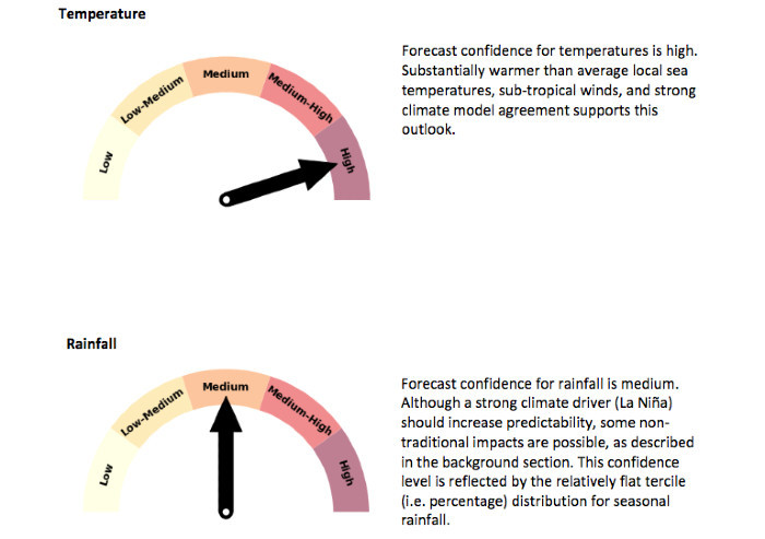
Forecast Confidence, according to the National Institute of Water and Atmospheric Research (NIWA).
In the east, some warming was observed closer to the surface.
“This likely indicates a progression toward a central Pacific La Niña, as opposed to a more traditional east-based event.
This could help to describe a summer season that has a mixture of drier westerlies and wetter northerlies in New Zealand.
“With La Niña’s peak expected in early 2021, tropical trade winds are expected to continue to be stronger than average over the next several months.
“While La Niña is expected to be the primary planetary climate driver over the next 3-6 months, an eastward advancement of the West Pacific warm pool was noted at depth in the equatorial Pacific during November.
“Should the advancement of this warm pool continue, it could cause a transition away from La Niña during mid-2021.
“According to the consensus from international models, the probability for La Niña conditions is 97% for December 2020 – February 2021. For March–May 2021, the probability for La Niña is 57% and 42% for ENSO-neutral conditions.
“During June –August 2021, ENSO neutral conditions are favoured (56% chance). During November, marine heatwave conditions formed in the north of the North Island, extending east and west of the region into the Pacific and Tasman Sea.”
Coastal water temperatures also warmed notably in the east of both islands and west of the South Island.
This outlook favours the continuation of unusually warm seas, with marine heatwave conditions possibly developing in other regions.
“Abnormally warm ocean temperatures can have a profound impact on air temperatures over land and provide fuel to cyclones approaching from the north.
“The marine and fisheries sectors should keep an eye on this evolving situation, as it could be similar to what occurred in late 2017-early 2018.”