M8.1 Kermadec Earthquake and Tsunami Threat - UPDATE
Staff Reporter
04 March 2021, 9:49 PM
 There is a Tsunami Warning for New Zealand coastal areas following the magnitude 8.1 earthquake near the Kermadec Islands Region
A Tsunami Warning has been issued following the M8.1 earthquake north-east of New Zealand near the Kermadec Islands region.
GNS Science has advised that the largest waves have now passed, and therefore the threat level is now downgraded to a Beach and Marine threat for all areas which were previously under Land and Marine threat.
All people who evacuated can now return.
The advice remains, for all areas under Beach and Marine threat, to stay off beach and shore areas.
We expect New Zealand coastal areas to experience strong and unusual currents and unpredictable surges at the shore following a magnitude 8.1 earthquake near KERMADEC ISLANDS REGION at 2021-03-05 8:28 AM.
Strong currents and surges can injure and drown people. There is a danger to swimmers, surfers, people fishing, small boats and anyone in or near the water close to shore.
People in or near the sea in the following areas should move out of the water, off beaches and shore areas and away from harbours, rivers and estuaries.
AREAS UNDER THREAT:
The West Coast of the North Island from CAPE REINGA to MAKARA including the West Coast of Auckland, Manukau Harbour, New Plymouth, Whanganui and the Kapiti Coast,
the East Coast of the North Island from CAPE REINGA to LAKE FERRY including Whangarei, GREAT BARRIER ISLAND, the East Coast of Auckland, Waiheke Island, Waitemata Harbour, Tauranga, Whakatane, Opotiki, Gisborne and Napier,
the West and South Coasts of the South Island from FAREWELL SPIT to THE CATLINS including Westport, Greymouth, Hokitika and Invercargill,
the top of the South Island from FAREWELL SPIT to PORT UNDERWOOD including Nelson, Picton and the Marlborough Sounds,
the East Coast of the South Island from the WAIPARA RIVER to the RAKAIA RIVER including Christchurch and Banks Peninsula, and from the TAIERI RIVER to THE CATLINS,
STEWART ISLAND,
and the CHATHAM ISLANDS.
There is no tsunami threat in all other areas.
ADVICE FOR PEOPLE IN AREAS UNDER THREAT:
STAY OFF THE BEACHES AND SHORE AREAS
Coastal inundation (flooding of land areas near the shore) is not expected as a result of this event. We are advising people to:
- Move out of the water, off beaches and shore areas and away from harbours, rivers and estuaries.
- Do not go to the coast to watch the unusual wave activity as there may be dangerous and unpredictable surges.
- Listen to local civil defence authorities and follow any instructions.
- Share this information with family, neighbours and friends
- Return home if you have evacuated.
Strong and unusual currents and unpredictable surges will continue for several hours and the threat must be regarded as real until this Advisory is cancelled.
This National Advisory has been issued following an assessment of information available. The situation may change as new information becomes available. Listen to the radio or TV for updates, or check www.civildefence.govt.nz
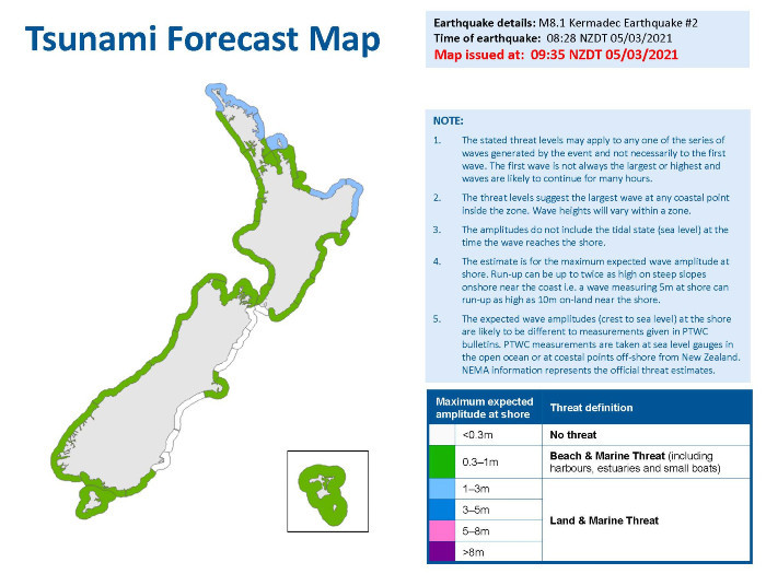
M8.1 Kermadec Earthquake Tsunami Forecast Map
The first waves may reach New Zealand in the areas around Lottin Point at approximately 9:49am New Zealand Daylight Time.
The severity of currents and surges will vary within a particular coastal area and over the period this warning is in effect.
The first wave may not be the largest. Tsunami activity will continue for several hours and the threat must be regarded as real until this warning is cancelled.
People in all New Zealand coastal areas should:
- Listen to the radio and/or TV for updates, and NZCivilDefence Twitter
- Listen to local Civil Defence authorities
- Stay out of the water (sea, rivers and estuaries, this includes boats)
- Stay off beaches and shore areas
- Do not go sightseeing
- Share this information with family, neighbours and friends
Do not return until an official all-clear message is given by Civil Defence.
Walk, run or cycle if at all possible to reduce the chances of getting stuck in traffic congestion.
The first wave may not be the largest. Tsunami activity will continue for several hours and the threat is real until this warning is cancelled.
People who are near the coast in the AREAS UNDER THREAT listed above or near the coast and felt the earthquake LONG OR STRONG, should MOVE NOW. DO NOT WAIT for an Emergency Mobile Alert to your mobile phone. Move to the nearest high ground, out of tsunami evacuation zones, or as far inland as possible.
The National Emergency Management Agency and GNS Science will continue to assess the threat and will provide an update for all areas as soon as possible.
Remember, Long or Strong, Get Gone.
Drop, Cover and Hold during the shaking. Protect yourself from the earthquake first.
As soon as the shaking stops, move immediately to the nearest high ground, out of all tsunami evacuation zones, or as far inland as possible.
NEMA (National Emergency Management Agency) have a great website with information on what to do before, during and after a tsunami.
There you can also find tsunami evacuation zone maps for around New Zealand, and what supplies you need in an emergency.
Only messages issued by the National Emergency Management Agency (NEMA) represent the official warning status for New Zealand. Pacific Tsunami Warning Center (PTWC) messages do not represent the official warning status for New Zealand.
This warning will remain in effect until a cancellation message is issued by the National Emergency Management Agency.
The following information is courtesy of NEMA:
Published: Fri Mar 5 2021 9:10 AM
Updated: Fri Mar 5 2021 12:15 PM


