Central business helps with fishing surveillance

Anna Robb
14 August 2022, 6:16 PM
 Typical long-liner vessel operating in Tuvalu. PHOTO: New Zealand Defence Force during a patrol flight in May 2022
Alexandra is a long way from the ocean, but a business whose head office is based in the township is working with a Pacific nation to understand illegal and unregulated fishing in its waters.
Starboard® Maritime Intelligence is a team of remote sensing and data scientists, software engineers and designers, and business and communication experts.
The team has worked for NASA and the European Space Agency, tech startups, aircraft manufacturers, humanitarian organisations, and academic institutions.
The Central App took a close look at how Starboard is also helping Tuvalu to detect illegal fishing vessels.
Nearly 60 satellite scans of Tuvalu’s exclusive economic zone (EEZ) have been obtained in the past nine months, thanks to a pilot project under the World Bank-funded Pacific Islands Regional Oceanscape Program (PROP).
Satellites, using new cutting-edge technology, were tasked to scan Tuvalu’s EEZ to detect ‘dark’ (illegal, non reporting) fishing vessels.
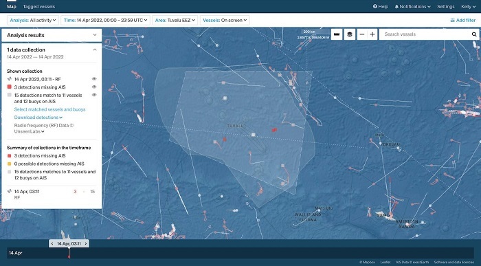
Starboard Maritime Intelligence showing radio frequency detections of potential illegal vessels (red spots) in Tuvalu. The large footprint (quadrangle) of satellite detection means a single data acquisition covers 80 per cent of Tuvalu’s zone
This technology is closing the surveillance gap for large ocean areas, the plan being to reduce the millions lost to illegal, unreported and unregulated fishing.
Fisheries are of critical importance to the Pacific. Illegal tuna fishing in the region is estimated to be 200,000 tonnes per year.
For many Pacific nations the licence fees from boats fishing in their EEZ is a major part of their annual income.
Fisheries compliance advisor Francisco Blaha said what Tuvalu is doing is important, because access fees paid by foreign vessels fishing their waters represent more than 55 per cent of government revenue.
“Anyone fishing illegally causes a direct hit to the economic viability of the country.”
Each satellite scan, covering up to 80 per cent of Tuvalu’s EEZ (750,000 km2) is applied for the first time in this region.
Different types of satellite sensors are used for detection, including mapping the locations of navigational radars aboard ships, and imaging of the ocean surface using synthetic-aperture radar.
Satellite detections and the positions of known vessels are automatically matched in
the Starboard digital platform.
Any vessels detected not reporting their locations using the mandated identification systems are highlighted as potentially fishing illegally and trying to evade identification.
Supporting countries such as Tuvalu to harness the potential of their fisheries resources in a sustainable way lies at the heart of poverty reduction.
World Bank PROP project team leader Iretomiwa Olatunji said combating illegal fishing through conventional approaches, supported by technology such as satellite monitoring, is key to reducing poverty.
These new technologies and the merging of different types of data can significantly enhance fisheries monitoring, control and surveillance, nevertheless there is a steep learning curve ahead for fisheries and stakeholders.
Starboard Maritime Intelligence’s senior scientist Dr Moritz Lehmann said over the past year or so more than a dozen new commercial vessel-detection satellites have come online.
“Before the end of 2023 we expect dozens more, which means we are quickly closing the surveillance gap.”
Read more about Xerra, the creators of Starboard in the earlier The Central App story: Xerra’s three Biosecurity Awards
Learn more about Starboard here.